


PEYRE ARSE PUY MARY

nordan
User
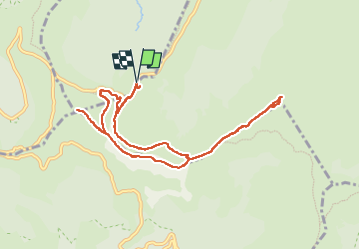

Length
10.1 km

Max alt
1786 m

Uphill gradient
615 m
Km-Effort
18.2 km

Min alt
1416 m

Downhill gradient
614 m
Boucle
Yes
Creation date :
2024-08-26 08:14:07.398
Updated on :
2024-08-31 13:10:45.016
3h24
Difficulty : Medium

FREE GPS app for hiking
 SityTrail
IGN / Geographical institutes
SityTrail Plus
The world is yours!
About
Trail Walking of 10.1 km to be discovered at Auvergne-Rhône-Alpes, Cantal, Le Claux. This trail is proposed by nordan.
Positioning
Country:
France
Region :
Auvergne-Rhône-Alpes
Department/Province :
Cantal
Municipality :
Le Claux
Location:
Unknown
Start:(Dec)
Start:(UTM)
475326 ; 4995531 (31T) N.
Comments